

The stratigraphic sequences below the surface of the Changhua area are the Quaternary Holocene, Pleistocene alluvial strata, the Quaternary Pleistocene palaeozoic strata, the Tertiary Pliocene Zhuolan layer, the Jinshui shale layer and so on. According to the hydrogeological survey and research results of the "Taiwan Area Groundwater Observation Network Overall Plan", the strata within 300 meters below the surface of the area belong to the Quaternary Holocene modern alluvial layer. During the deposition process, four major As the sea enters and retreats, as a result of the alternating cycles of continental and marine sedimentary cycles, an aquifer system in which the underground aquifer and the water-blocking layer interlaced in the alluvial fan-tail coastal area is formed, can be divided into aquifer one and water blocking from top to bottom The main eight strata are from layer one to aquifer four and water blocking layer four. According to the “G0001 Turbidity Stream Alluvial Fan Planning Plan for Groundwater Recharge and Geological Sensitive Zones” announced by the Ministry of Economic Affairs on March 4, 2014, the summary is as follows:
The surface of the surface of the fan roof of the Zhuoshuixi alluvial fan is covered by the Holocene alluvial layer, which is unconsolidated sediments, mainly composed of gravel, sand and mud, distributed on the riverbed of the existing river, the Bagua hills and the west of the Douliu hills. Alluvial plains. The alluvial plain is mainly formed by the alluvial alluvium of Zhuoshui Stream, Lugang Stream, Huwei Stream, and other east-west rivers, while the Douliu Hill is mainly composed of the conglomerate of the Pleistocene Fire Mountain conglomerate section of the Pyongsongtou Mountain, thick sandstone and sandstone. It consists of the Xiangshan sandstone section of the Toushan layer composed of shale and the Early Pleistocene Zhulan layer composed of fine-grained to silty layered sandstone; the Bagua hills are mainly composed of the Huoyanshan conglomerate section of the Toushan layer , Including the late slope of the Pleistocene to Holocene, composed of muddy gravel layer of slope slope accumulation. The lithological changes and distribution of the groundwater layer and water blocking layer of Zhuoshuixi Alluvial Fan are described as follows:
1. Groundwater layer one(F1)
The groundwater layer is the most surface layer of the hydrogeological system in the Zhuoshuixi alluvial fan area. The distribution range covers the whole area, from the surface to the deepest about 103 meters, the thickness varies from 19 to 103 meters, and the average thickness is 42 meters. This layer is mainly composed of gravel layer and coarse sand layer near the top of the alluvial fan, and its thickness is large; to the fan center and fan tail, the lithology gradually changes into fine sand layer and mud layer, and the surface and interior of groundwater layer 1 often have good extension The thick mud layer is distributed, causing the local groundwater layer to be confined or segmented. The gravel layer and sand layer in the independent fan-shaped area located near the southeast corner of the Zhuoshuixi alluvial fan are thicker than 110 meters. The surface terrain is composed of several small alluvial fans in the foothills of the Douliu Hill, and is combined with the Zhuoshuixi fan The topography can be clearly distinguished. It is speculated that this huge thick gravel has a considerable ratio to the sand layer provided by Douliu Hill; the thickness of the alluvial fan roof of Zhuoshui Stream is the second largest, which can be greater than 60 meters; the thickness of the fan is the smallest, often less than 20 The thickness of the fantail, which is near the coast, increases to about 30 to 40 meters, which should be related to the deposition of marine sand.
2. Aquitard 1 (T1)
The aquitard 1 is located below the groundwater layer 1, and is widely distributed in the alluvial fan center and fan tail. Its west side extends into the sea, while the east side is sharpened at more than ten kilometers away from the Zhangyun Bridge. The maximum thickness is 39 meters, and the average thickness is about 14 meters. This layer is mainly a mud layer, that is, it is composed of clay, mud or silt layer, with a fine sand layer and a few coarse sand layers locally.
3. Groundwater layer two (F2)
Below aquitard 1 is groundwater layer 2. Its distribution range covers the whole area, the depth is between 35 and 217 meters below the surface, the thickness varies from 76 to 145 meters, and the average thickness is about 95 meters. The thickest layer. This layer is dominated by gravel and coarse sand layer near the alluvial fan roof, and there is no obvious separation of water blocking layer from groundwater layer one. The particle size of the fan center and fan tail material is thinner, but there are still coarse sand or gravel layers, showing the importance of the widely distributed groundwater layer 2 in the region's water storage and water supply. In some areas, the groundwater layer 2 is sandwiched by 2 to 3 layers of mud with a large extension range. These mud layers have a partial division effect on the groundwater layer. However, considering that its distribution range and thickness are relatively less than 4 main water-blocking layers, so It is only classified as the convex mirror body of the mud layer in groundwater layer 2, not named individually. It is shown that the thickness of the gravel layer and sand layer of the alluvial fan roof of the Zhuoshui Stream is the largest, which can be greater than 130 meters. The Zhuoshui Stream is the main source of sediments. The Douliu Hill should not provide significant sediments; the northeast side and the Meiyi area have a fan-shaped area. The thickness can reach 80 meters, which seems to be part of the Wuxi alluvial formation and the American alluvial fan; the total thickness of the fan tail sand layer and gravel layer is the smallest, ranging from 50 to 70 meters.
4. Aquitard two (T2)
The aquitard 2 is located below the groundwater layer 2, and is widely distributed in the alluvial fan and fan tail, and its west side extends into the sea; the water-blocking layer 2 has a maximum thickness of 46 meters and an average thickness of about 23 meters, mainly composed of mud layers and fine sand layers , Partly sandwiched with coarse sand.
5. Groundwater layer three (F3)
Below aquitard 2 is groundwater layer 3. Its distribution range also covers the whole area. Its scale is slightly smaller than that of water-rich layer 2. The depth is between 140 and 275 meters and the thickness is between 42 and 122 meters. The groundwater layer in the area north of Zhuoshui Stream is far more developed than the south, and the average thickness of the whole area is about 86 meters.
6. Aquitard three (T3)
The aquitard three is located below the groundwater layer 3, and the area north of Zhuoshui Stream has a small thickness and a small distribution range. The maximum thickness of the water-blocking layer 3 is about 28 meters, and the average thickness is about 11 meters. It is composed of mud layers and fine sand layers.
7. Groundwater layer four (F4)
Below aquitard 3 is the groundwater layer 4. Because its average depth is greater than 271 meters, only 14 wells in the region exceed this depth, of which 9 penetrated this layer and 5 did not reach the bottom of this layer. It is difficult to make a clear description of the groundwater layer 4 and aquitard 4 in the whole area. Basically, the gravel layer and coarse sand layer are still dominated near the fan roof, and the phase transition to the fan center and fan tail is mainly made of fine sand. The distribution depth is between 238 and 313 meters, the thickness is between 6 and 51 meters, and the average thickness is about 24 meters, which is the smallest thickness of each groundwater layer.
8. Aquitard 4 (T4)
The thick mud layer beneath the groundwater layer 4 is the water-blocking layer 4. Since the bottom depth exceeds the drilling depth, it is impossible to truly understand the overall thickness and lithology changes. Generally, this layer is composed of thick mud layer with fine sand and a small amount of coarse sand layer. The maximum thickness is above 52 meters, the top depth is between 255 and 313 meters, and the nature and depth of the bottom are unknown.
According to the Central Geological Survey of the Ministry of Economic Affairs (1995), a conceptual map of the geological section of the Zhuoshuixi Alluvial Fan was drawn. As shown in the attached figure 3-1.2, the recharge area is mainly in the Fanding area, although the Bagua Mountains all contain the high-permeability Jose Mountain. Under the influence of the height of the Bagua Mountain Range, the groundwater flow still mainly flows and recharges to both sides with the mountain ridge line. Therefore, the recharge of the alluvial fan roof of the Zhuoshui Stream mainly comes from the lateral recharge of the mountainous area. The Central Geological Survey (1999) of the Ministry of Economic Affairs (1999) in the hydrogeological survey of Changhua area, the location of the quality drilling sites and 4 sets of stratum profile lines, as shown in Figure 3-1.4 The thickness of the sediment and its extension, the geological characteristics of each section are described as follows:
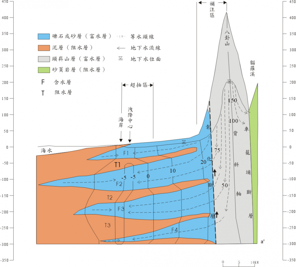
Figure 3-1.2 Conceptual model of hydrogeology of Zhuoshuixi alluvial fan (Lai Dianzhang et al., 2003)
Figure 3-1.4 Distribution map of hydrogeology profiles in Changhua area (profiles 1 to 4)
1. Tanaka-Quanxing section (with figure 3-1.5) There are 7 drilling points in this section from Tanzhong along the north via Yuanlin, Huatan, Dongfang, Dingfan, and west of the line to Quanxing. In the middle of the field, there is a thick layer of gravel, and a thin layer of mud occasionally appears deep in the core. Surface water or rainwater can quickly infiltrate; between Yuanlin and Quanxing, most of them are mainly gravel and mud layers, below the surface There is a continuous mud layer at about 20 to 50 meters, and then there is a layer of coarse, fine sand and gravel, and even a discontinuous mud layer. This section is covered with mud layers of varying thickness of about 5 to 20 meters near the surface. There is no such mud layer only in the west of the line. The barrier of the mud layer makes it difficult for surface water or rainwater to infiltrate quickly; extending from the flower bed to the north The west of the fantail line, within 200 meters below the surface, is mainly composed of mud layers between medium and fine sand layers, but there is a gravel layer about 10 to 30 meters thick between 90 and 120 meters deep, and 170 meters below the surface There are occasional gravel layers around.
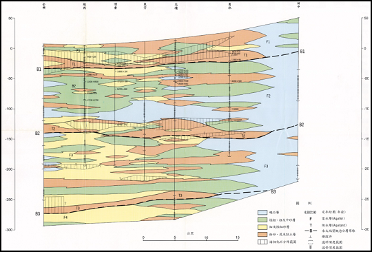
Figure 3-1.5 Hydrogeological section of "Tanaka-Quanxing" section in Changhua area
2. Tanaka-Hanbao section (with figure 3-1.6) This section starts from Tanaka, passes through Xihu, Haoxiu, Wenchang, Luojin and Hanbao, and counts 6 drilling points. The geology east of Haoxu is composed of gravel, sand and mud. The gravel layer can extend to the Tianzhong area, forming a good groundwater circulation channel; from Wenchang to the southwest to the coastal area, the coarse, medium sand layer, mud layer, gravel It is mainly composed of layers, but its lithological extension is not good; there is a continuous mud layer about 5 to 15 meters thick between the Xihu and Hanbao about 20 to 50 meters below the surface, and the surface is between Xihu and Luojin It is covered with a mud layer of about 5 meters thick, which is easy to block the infiltration of rainwater.
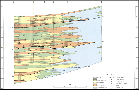
Figure 3-1.6 Changhua area "Tanaka-Hanbao" section hydrogeological section
3. Ershui-Fangyuan section (with figure 3-1.7) This section runs from Ershui westward to Orange Garden, Xizhou, Yuandou, Zhaojia, and Fangyuan, with 7 drilling points in total. From the east of the original bucket, mainly to the gravel layer; to the west of the original bucket, from 80 meters below the surface, the sand layer and the mud layer are staggered, and from 80 to 140 meters below the surface, the gravel layer and coarse sand (to the seashore) There are still gravel layers in the area), 140 to 180 meters below the surface is a well-extended mud layer, and 180 to 200 meters below the surface are mainly coarse, medium sand and gravel; on the road to Orange Park There is a continuous mud layer of about 5 to 10 meters thick at the surface to block rainwater from directly infiltrating into the gravel layer west of Ershui; a thick water blocking layer of about 10 to 20 meters appears under the surface of Xizhou to Fangyuan; the original The area west of Douyi is mostly where sand and mud strata interact.
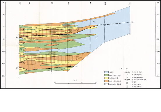
Figure 3-1.7 Changhua area "Ershui-Fangyuan" section hydrogeological section
4. Tanaka-Xigang section (with figure 3-1.8) This section starts from Tanaka in the east, passes through Tianwei, Hexing, Zhutang, Yongan, Tanbing to Xigang, and has 7 drilling points. There is a mud layer about 5 to 10 meters thick near the surface between Tianwei and Tanqian; the distribution of the gravel layer is roughly delimited by bamboo ponds, and mostly thick gravel to the east of bamboo ponds, except for Tianzhong, thick gravel All are located below the water blocking layer, even with mud layers, and the gravel layer west of Zhutang is thin and interbedded with sand and mud and is located below the water blocking layer; the coarse and medium sand layers west of Zhutang account for most of the core and constitute groundwater Good channel for flow.
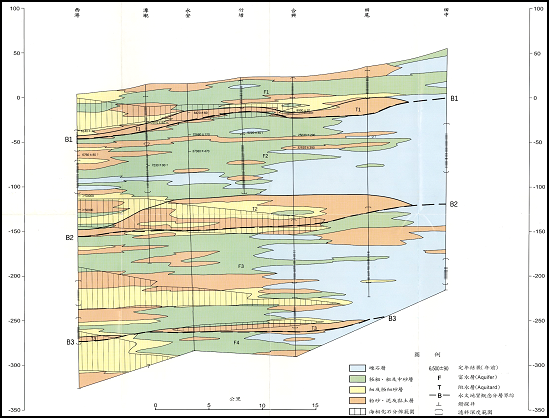
Figure 3-1.8 Changhua area "Tanaka-Xigang" section hydrogeological section
According to the above-mentioned hydrogeological survey of Changhua area, the quality drilling data (Table 5-1.4) mainly consist of clay and sand, and Xigang (2) has a higher clay ratio; the distribution of geological characteristics in Changhua area is shown in the figure. As shown in 5-1.12, the fan top has a higher proportion of gravel, while the fan center and fan tail have a higher proportion of clay and sand.
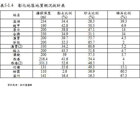

Figure 4-1.10 Changhua area geological characteristics distribution
References: 1. "Compilation of the results of the overall plan for the groundwater observation network in Taiwan (1992-2008)"
2. "Taiwan region hydrogeological zoning characteristics", Central Geological Survey, 1997.
3. Monitoring and analysis of formation subsidence in Taipei, Chiayi, Kaohsiung and Pingtung in 2015.
4. In 2014, diversified monitoring and integration technologies were applied to the monitoring of strata subsidence in Taipei, Changhua and Yunlin.