

According to the compilation of the results of the Groundwater Observation Network of the Ministry of Economic Affairs, the Chiayi area covers some areas of the Jianan Plain and Zhuoshuixi Alluvial Fan. The stratum subsidence area of Chiayi County is mainly located in the western area of Chiayi, which belongs to the northern area of the Chiayi Plain (north of Yanshui Creek) Is a sedimentary basin system; the geology of the Jianan Plain is dominated by fine-grained sediments, good rain-injection and infiltration, and the formations are mostly sand and interbeds, with obvious stratification but good continuity and good thickness variation (thick The height is less than 20 meters), there is no significant water blocking layer and aquifer, and the movement between the upper and lower groundwater is small. The stratum within the depth of about 220 meters in the area of the Jianan Plain can be divided into the first aquifer (mainly deep between 60 and 80 meters below the surface) and the second aquifer (about 80 to 120 meters below the surface), the third aquifer (distributed between 120 and 210 meters below the surface), because the drilling depth is only 250 meters below the surface, and the sand layer ratio of the groundwater layer below 210 meters below the surface It is extremely low, so it is difficult to judge it as an aquifer, so only the groundwater layer below 210 meters is attributed to the fourth aquifer.
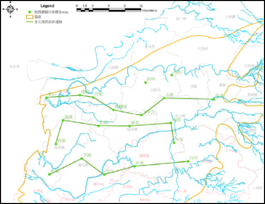
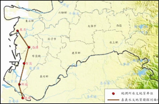
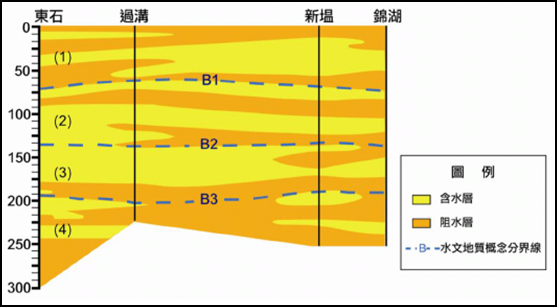
The hydrogeological survey of the Central Geological Survey of the Ministry of Economic Affairs in the Chiayi area shows the location of various quality drilling sites and its 4 sets of strata profile lines as shown in Figure 4-1.34 to Figure 4-1.35, and each hydrogeological profile as shown in Figure 4-1.36 to As shown in Figure 4-1.39.
Source: "National Yunlin University of Science and Technology Research Center for Water and Land Resources and Disaster Prevention 101 Years Implementation Plan" Final Report, Ministry of Economic Affairs, 2012
Figure 4-1.34 Distribution map of hydrogeological section in Chiayi area
Source: "2012 Diversified Monitoring and Integration Technology Applied to Strata Subsidence Monitoring in Yilan, Miaoli, Taichung, Chiayi, and Pingtung Regions" Final Report, Ministry of Economic Affairs, 2012
Figure 4-1.35 Chiayi coastal area hydrogeological profile distribution map
Source: Central Geological Survey, Ministry of Economic Affairs.
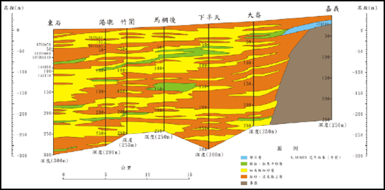
Figure 4-1.36 Chiayi area "Chiayi-Dongshi" section hydrogeological profile
Source: Central Geological Survey, Ministry of Economic Affairs.
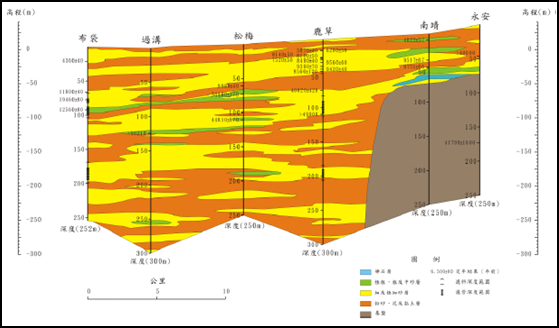
Figure 4-1.37 Chiayi area "Yong'an-Budai" hydrogeological section
Source: Central Geological Survey, Ministry of Economic Affairs.
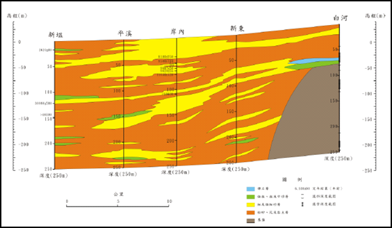
Figure 4-1.38 Chiayi area "Baihe-Xinya" hydrogeological section
Source: Central Geological Survey, Ministry of Economic Affairs.
Figure 4-1.39 Chiayi area "Dongshi-Jinhu" hydrogeological section
According to the drilling data of the hydrogeological survey in the significantly subsidence area of Chiayi (Table 4-1.3), the proportion of clay is quite high, among which Zhuwei, Pingxi and Mahou have a higher proportion of clay (over 80%) , Indicating that there is a relatively high subsidence potential (see Figure 4-1.40 for the distribution of geological characteristics).。
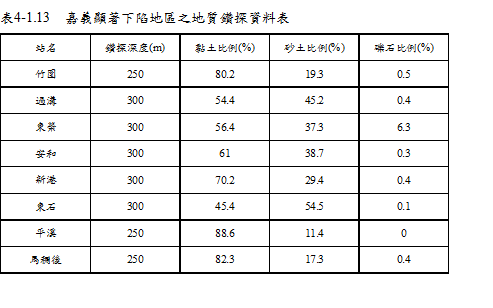
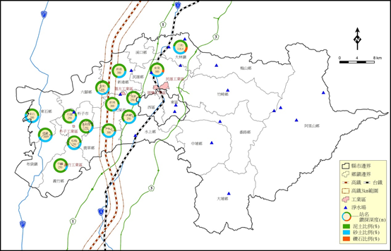
圖4-1.40 Figure 4-1.40 Geological characteristics distribution in Chiayi area
References: 1. "Compilation of the results of the overall plan of Taiwan's groundwater observation network (1992-2008)"
2. "Taiwan Area Hydrogeological Zoning Characteristics", Central Geological Survey, 2008.
3. 2015 Subsidence Monitoring and Analysis of Taipei, Chiayi, Kaohsiung and Pingtung