The Yilan Plain geological area is a Quaternary Holocene stratum, which is an alluvial layer composed of clay, silt, sand, and gravel. The Yilan Plain is a subsidence zone between the Snow Mountain Range and the Central Mountain Range. It is caused by the rupture of the Okinawa Trough. It extends eastwards and can be connected to the east of the Ryukyu Islands. It was later formed by the alluvial deposit of the main river of Lanyang Creek. Open alluvial fan delta plain (He Chunsun, 1982) (Figure 3-1‑1).
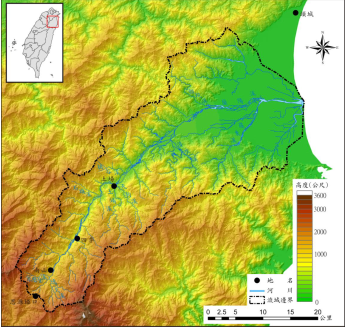
Figure 3-1‑1 Topography of Yilan Plain and Lanyang Creek Water System (Lin Shengqin, 2011)
The geology of the Yilan Plain is mainly composed of Lanyang Creek, Jinmian Creek, Fude Creek, Dezikou Creek, and Xincheng Creek, etc., carrying modern Quaternary alluvial layers. The alluvial layers are roughly horizontal, mainly composed of gravel, sand, It is composed of muddy fine sand and soil. Generally speaking, the alluvial particles gradually change from coarse grains upstream to downstream into muddy fine sands with poor permeability (Figure 3-1-2). According to the results of reflection seismic survey in the Yilan Plain, the alluvial layer showed a basin-like trend with a thickness of about 300 meters, and the thicker it was toward the center of the plain. The results of the Central Geological Survey's hydrogeological drilling in the Yilan Plain in 2000 and 2002. The thickness of the alluvium in the Yuanshan and Sanxing areas on the west of the plain is about 120-200 meters. The thickness of the alluvium in the Zhuangwei, Wujie and Luodong areas on the east of the plain 200 meters or more.
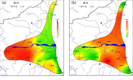
Figure 3-1-2 Distribution map of gravel (a) and mud (b) content in the Lanyang Plain (Lu Xueyu, 2001)
The Yilan Plain belongs to the Quaternary unconsolidated modern alluvial layer (He Chunsun, 1955; Yang Wanquan, 2000). During this period, it is porous and can store large amounts of water resources. It is the main source of groundwater. The groundwater flow network in the Yilan Plain can be roughly divided into three groundwater systems (Yang Wanquan, 2000), namely the Dezikou Stream Groundwater System, Lanyang Stream Groundwater System and Dongshan River Groundwater System.
On the whole, the groundwater source in the Yilan Plain is still abundant. The recharge area of groundwater is in the alluvial sectors above 5 meters from the west and south sides of the plain; the deltas from 2 to 3 meters on the east side are mostly composed of fine sand and mud Composition, poor permeability, is the outflow area; due to the good permeability of the alluvial fan, the poor permeability of the delta, groundwater easily flows out of the ground and continues to flow eastward. The water conductivity of the alluvial sector of the Yilan Plain is bounded by Lanyang Creek, with the south being better and the north being worse. According to the results of the drilling core study in the area south of Lanyang Creek (Figure 3-1‑3), the southernmost side of the Lanyang Plain (Figure 3-1‑3(b)) is affected by the Guluo Dongxi River Channel, which is relatively thick Aquifer; the distribution of the aquifer across both sides of Lanyang Creek (Figure 3-1‑3(c)) is irregular, and there are not many gravel layers. The aquifer is mainly coarse sand, and the deeper sediments are Mainly fine sand and mud.
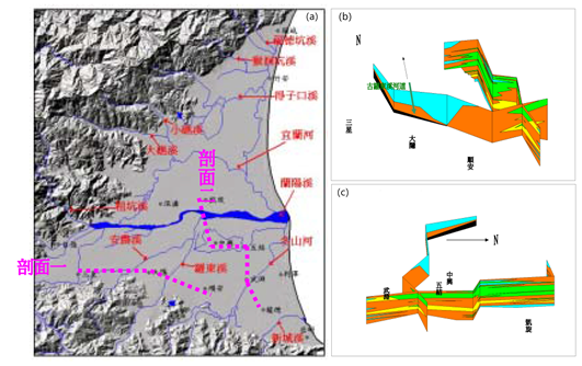
Figure 3-1-3 Lanzhou Plain Water System (a) and Hydrogeological Section (b) (c) Diagram (Lv Xueyu, 2001)
Because of the thick mud layer on the east side of the Yilan Plain (downstream area), its subsidence potential is high. Therefore, in the past, the vicinity of the Lanyangxi estuary and Zhuangwei Township and Wujie Township were the main subsidence areas in the Yilan Plain. The Lanyang Plain is located at the westernmost edge of the Okinawa Trough. The subsidence rate in the basin is very different. In addition, the seawater surface drop in the past 20,000 years has reached 120 meters. This has created a lithofacies in the Lanyang Plain. Alluvial plains, estuaries, coastal zones, intertidal zones and distant coastal zones are complex sedimentary environments.
Before 18,000 years, the global sea surface was about 120 meters lower than today, so most of the unconformity is formed under the Lanyang Plain. Afterwards, the sedimentary environment gradually became deeper and shallower upward. The sedimentary environment of the offshore well position was changed from the estuary bay or the coastal environment to the distant coastal environment, and then from the coastal surface to the alluvial plain environment. The sedimentary environment close to the well position on the mountain side changed from the alluvial plain downstream to the alluvial fan environment. In 6,000 years, the height of the global seawater surface reached its highest peak, and the sedimentary environment no longer became deeper. At this time, a large amount of sediment was filled into the sedimentary basin, the sedimentary environment quickly became shallower, and the coarse-grained sediment quickly moved to the sea side Accumulate to form a large-scale Lanyang alluvial plain today.
The groundwater system of the Lanyang Plain is controlled by the diversion of the ancient Lanyang Stream and the influence of the distribution range of alluvial fans, so the continuity of the groundwater layer is more irregular. Generally speaking, the sediment particles on the top (upstream) of the alluvial fan are coarser, and they often form a good groundwater layer; the sediments around the alluvial fan (middle and downstream) have a finer grain size and higher mud content, which affects the side of the groundwater layer. To continuous. On the west side of the plain, it is mainly the gravel layer deposited by the alluvial fan of Lanyang Stream, with a thickness of up to 200 meters; the thickness of the gravel layer to the east becomes thinner and the grain size becomes finer; to the coastal area, only the upper part is about 50 meters in the delta. The sedimentary sand layer is mainly composed of marine mud layer, and there is no better groundwater layer. Based on the results of various hydrogeological surveys, the 250-meter range below the surface of the Lanyang Plain was initially divided into 6 hydrogeological units, namely groundwater layer 1, water blocking layer 1, groundwater layer 2, water blocking layer 2, groundwater layer Three and water blocking layer three. Generally speaking, the use of groundwater is mainly in the shallow groundwater layer; the deeper groundwater layer (about 150 meters below) often has self-spraying phenomenon, and is less developed.
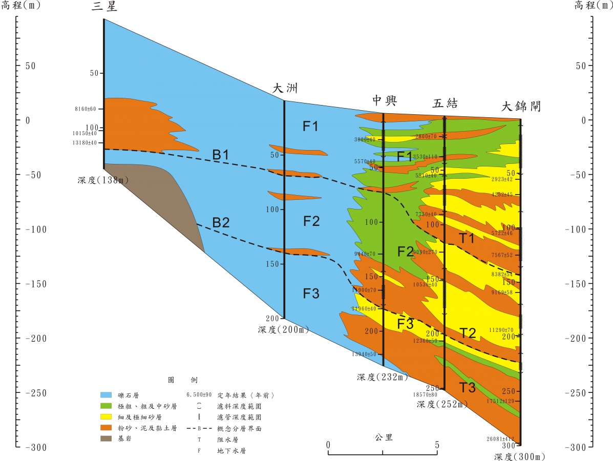
Figure 13.2-1 East-west hydrogeological section of Lanyang Creek
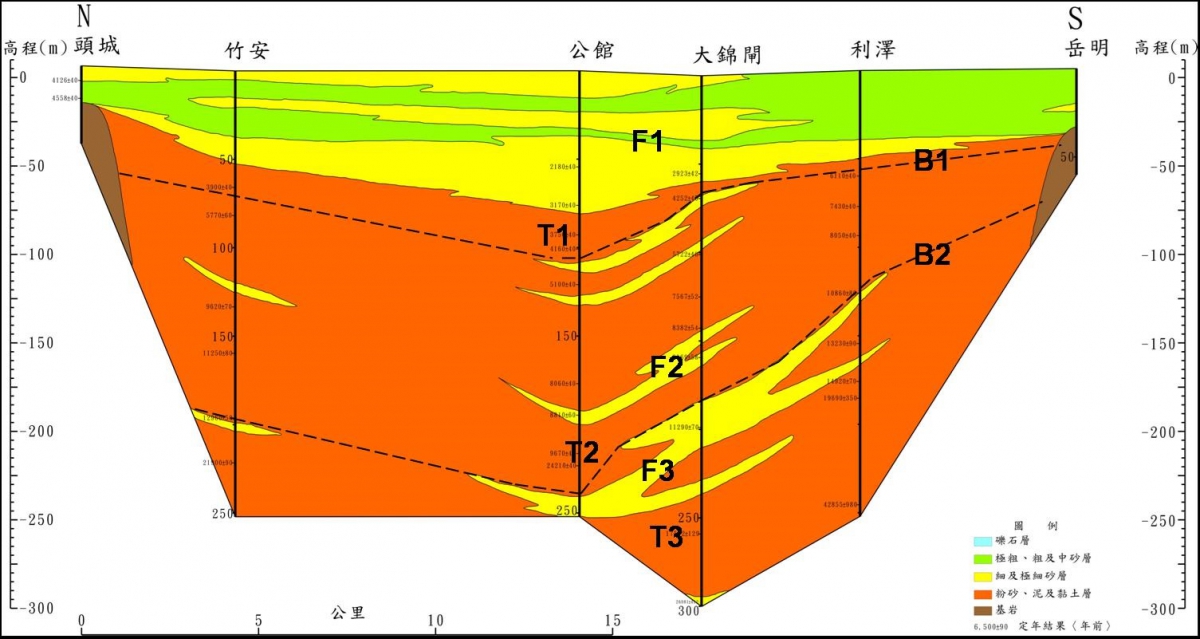
Figure 13.2-2 Hydrogeological profile of the north-south coast of the Lanyang Plain
references:
1. "Compilation of the results of the overall plan for the groundwater observation network in Taiwan (1992-2008)"
2. "Taiwan Area Hydrogeological Zoning Characteristics", Central Geological Survey, 2008.
3. Monitoring and analysis of formation subsidence in Taipei, Chiayi, Kaohsiung and Pingtung in 2015

