

According to the topographical characteristics of the area, the Taichung area can be divided into two different sedimentary environments. One is the Taichung Basin east of the Dadu Mountain Platform and the Bagua Mountain Platform, and the other is the Qingshui Coastal Plain west of the Datong Mountain Platform. Dali well and Wuri well are located in Taichung basin, where Dali well is located in the secondary environment-Taipian alluvial fan in Taichung basin, while Wuri well is located under compound fan skirts such as Fengyuan alluvial fan and Taiping alluvial fan Fan. As for the other five wells such as Datujing, they are all located on the Qingshui Coastal Plain. Among them, the Dadujing and Zhonghe wells are located in the secondary environment of the Qingshui Coastal Plain, respectively. The Qingshui Well is located in the Qingshui Coastal Plain, where the Wuxi Well is located in the coastal zone, and the Qingshui Well is located on the small alluvial fan at the front edge of the Datu Mountain Platform, and the Gaomei Well is located on the river bed downstream of the Dajia Stream.
Based on the analysis of sedimentary facies, the combination of sedimentary facies such as alluvial fans, braided rivers, meandering rivers, flood plains, ponds, swamps, and estuaries can be identified in Taichung. According to the stratigraphic columns of each sedimentary facies, the lithological characteristics of the sedimentary layers in each well and their vertical changes are closely related to the topographic environment of the well. For example, the Dali and Qingshui wells in the Taichung area are located on the alluvial fan, so the cores under the well are mainly composed of the sedimentary facies of the alluvial fan and its related sub-environment. The Zhonghe and Wuqi wells in the lower reaches of the river and the coastal plain near the seaside are dominated by sedimentary facies such as meandering rivers and estuaries. In addition, the Wuri and Gaomei wells beside the Daduxi and Dajiaxi rivers were deposited by river action.
The geochronological analysis of this area is based on the carbon 14 dating results of four drilling wells in the Taiyuan coastal plain. The sedimentary age of the formations above 50 meters in depth ranged from about 10,000 to 5,000 years ago, which is quite close to the maximum advancing period of the Holocene. ; The sedimentary age of the formation below 50 meters in depth is estimated to be hundreds of thousands of years. The stratum of the Taichung Basin is mainly gravel, and there is no suitable specimen for the analysis of carbon 14 dating. It is speculated that its sedimentary age is hundreds of thousands of years. The sedimentary age of the strata above 450 meters ranged from about 10,000 to 5,000 years ago, which is quite close to the maximum transgression period of the Holocene; the sedimentary age of the strata below the depth of 50 meters is presumed to be hundreds of thousands of years. The stratum of the Taichung Basin is mainly gravel, and there is no suitable specimen for the analysis of carbon 14 dating. It is speculated that its sedimentary age is hundreds of thousands of years.
The preliminary analysis of the hydrogeology of this area is in the piedmont zone outside the western piedmont zone in Taiwan. According to the topographic characteristics, the Taichung area can be divided into two groundwater zonings: the Dadushan platform and the Taichung basin east of the Bagua mountain platform. And the Qingshui Coastal Plain to the west of Dadu Mountain Platform.
The Taichung Basin is located between the Chelongpu Fault and the Changhua Fault. It is a structural basin in the outer foothill zone, which is long and narrow in the north and south. The Dali and Wuri wells drilled in 2015 are located in this basin. According to the data from the observation wells of Dali Station and the Water Resources Department this year, the northern and eastern basins are dominated by thick layers of gravel deposited by alluvial fans, and there are no obvious water-blocking layers; in the Uri area on the west side of the central basin, strata Thick layers of gravel are still dominant, but several layers of sand and mud are sandwiched between the depths of about 45-55 meters and 101-118 meters to form a regional water-blocking layer, as shown in Figure 7.2-1.
Based on the cores of Gaomei, Qingshui, Wuqi, Dadu and Zhonghe stations in the Qingshui Coastal Plain area of Taichung in 2005, two north-south hydrogeological profiles (Figure 7.2-2 and Figure 7.2-3) were drawn. The area west of the coast of Taichung (Gaomei, Wuxi, Zhonghe Section) to 250 meters below the surface can be roughly divided into 4 aquifers and 3 Aquifuge. The characteristics of each layer are:
(1) Aquifer 1: The Wuqi to Zhonghe area is mainly composed of fine sand to very fine sand. In the Gaomei area, due to its proximity to Dajia Stream, there are thick gravel on the top.
(2) Aquifuge 1: The depth is about 50 meters deep, which is composed of a thin mud layer, and the thickness of the mud layer in Zhonghe area is relatively thick.
(3) Aquifer 2: mainly composed of gravel and medium sand, occasionally with thin and fine sand layer, the depth is about 50-110 meters deep, there are thick gravel at the Gaomei Station near Dajiaxi, near the seashore The Wuxi Station and Zhonghe Station are mainly composed of medium sand with occasionally thin sand layers.
(4) Aquifuge 2: Mainly mud and fine sand layer, the depth is about 110-130 meters deep.深。
(5) Aquifer 3: Mainly gravel, sandwiched with sand and fine sand, the depth is about 140-190 meters deep, and the layer thickness of each station is greater than 50 meters, which is an excellent aquifer.
(6) Aquifuge 3: Mainly mud and fine sand layer, the depth is about 190-210 meters deep.
(7) Aquifer 4: Dominated by medium sand with a depth of about 210 meters or less (Figure 7.2-2).
In the Qingshui and Dadu stations near the front edge of the Dadu platform, the drilling depth is only 150 meters, which can be roughly divided into 2 aquifers and 1 Aquifuge. The characteristics of each layer are as follows: (1) Aquifer 1: mainly composed of fine sand, the depth is about 10-30 meters deep. (2) Water-blocking layer 1: The depth is about 50 meters deep, and it is composed of a thin layer of mud. (3) Aquifer II: It is mainly composed of thick gravel and thin sand layer. It is located below the depth of 40 meters at Dadu Station and below 60 meters at Qingshui Station. This layer is an excellent aquifer (Figure 7.2-3).
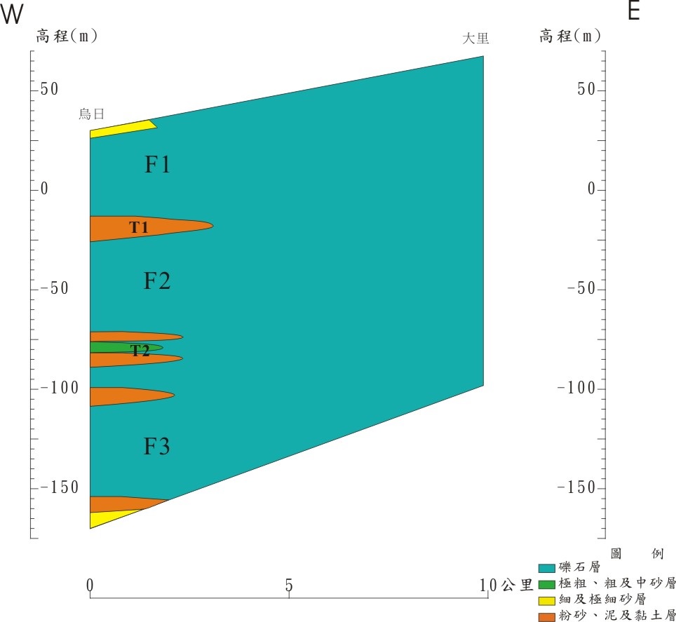
Figure 7.2-1 East-west section of Taichung Basin
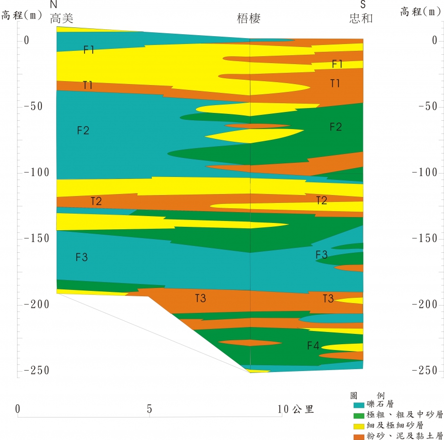
Figure 7.2-2 Hydrogeological profile on the west side of Taichung Coast
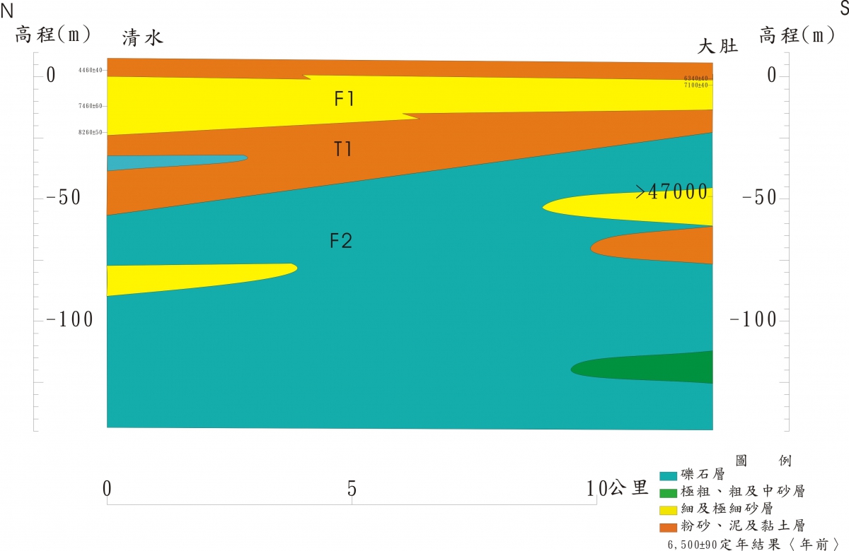
Figure 7.2-3 North-south hydrogeological section of the east coast of Taichung