The Taipei Basin is surrounded by faults and is a structural basin (Lin Chaowei, 1957; Wang Zhiming et al., 1978). There are several faults passing through the basin and across the Taipei Basin. From the northwest to the southeast, there are Jinshan fault, Xinzhuang fault, Shanjiao fault, Kanjia fault, Taipei fault, Luntou fault (Chengfu fault) and Xindian fault, among others; The Shanjiao fault is a normal fault formed in the Quaternary, and the remaining faults are all reverse fault structures formed during the Quaternary orogeny. These fault structures not only have a close relationship with the formation of the basin, but also control the appearance of the basin and the morphology of the basin base (Lin Chaozong, 2001). The strata of the Taipei Basin are covered by modern alluvial layers of the Quaternary period; the areas surrounding the foothills and terraces of the Taipei Basin are composed of sedimentary rocks and Quaternary volcanic rocks from the Tertiary to Quaternary periods; :
(a) The hilly mountains on the southeast side; composed of sedimentary rocks of the Tertiary period.
(b) The volcanic zone on the north side; composed of Quaternary Pliocene to Pleistocene volcanic rocks.
(c) The west side platform; it is composed of Quaternary strata such as the Ptoeolithic Seongshan stratum and the laterite platform accumulation layer (as shown in Figure 3.1-2).
The underground aquifers in the Taipei Basin are mainly Quaternary alluvial layers. The Tertiary sites, except for the Pliocene, with strong weathering and fissures, almost contain no groundwater. Jia Yiping (1999) distinguishes the unconsolidated sediments above the rock disks of the basin into two regions of hydrogeological units. The deep gravel and sandy sediments constitute the main aquifer in this area, while the upper part is covered with a Muddy sediment-based aquitard (that is, water barrier or confinement layer), which is the main source of formation subsidence.
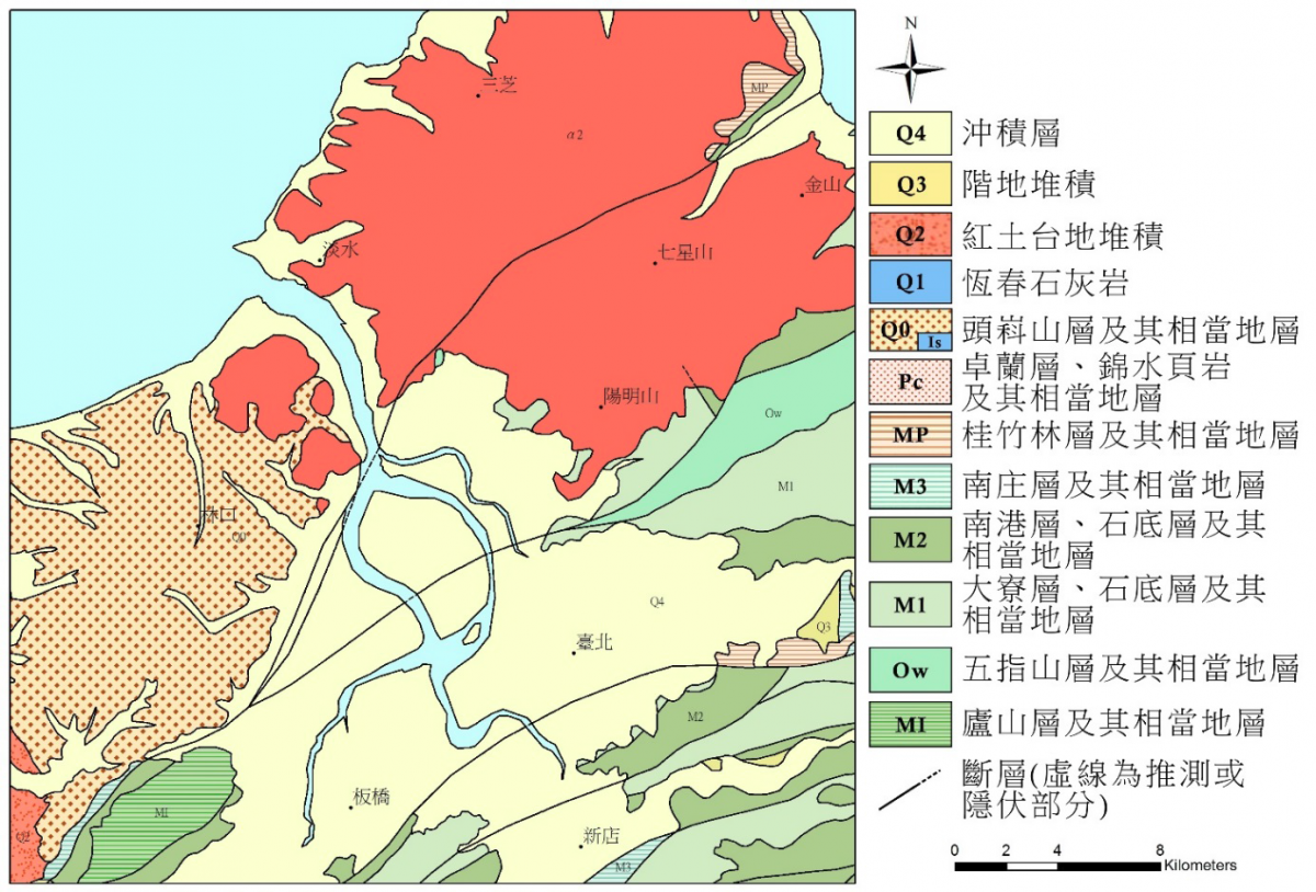
Figure 3.1-2 The regional geological map of the Taipei Basin (modified from the Central Geological Survey, 2000)
Note: The accuracy of the original geological map is one half a million geological map
The hydrogeology of this area (Figure 4.2-1) should be controlled by the sedimentation of ancient Xindian Creek and Dahan Creek. Jingmei and Banqiao should be the current groundwater replenishment area. 50~100 meters, forming a regional water blocking layer.
The depth of Jingmei layer is about 50~150 meters, which is the main aquifer (regional second aquifer) in this area. The groundwater level of this layer is the highest in the recharge area (Jingmei and Banqiao), about 2~8 meters above sea level ( 2001,June), gradually lowering to the north, the lowest in Xinzhuang area, about -11 meters above sea level.
The shallow groundwater layer is mainly composed of gravel with very good permeability, with a thickness ranging from 29 to 128 meters. The thickness of the groundwater layer in the west of the basin is thick, and its permeability is excellent. The deep groundwater layer is dominated by a gravel layer, and the shallow groundwater is the same deep groundwater as the groundwater under pressure.
The Tertiary base is the bottom of this layer. The shallow water-blocking layer is located below the surface, and the distribution range covers almost the entire Taipei Basin, with a thickness between 40 and 60 meters.
The lithology is dominated by muddy sediments with several thin layers of sand, but most of the sand layers are sharply extinguished when they extend laterally, so they only constitute a local secondary groundwater layer. The thickness of the deep water blocking layer is approximately between 20 and 50 meters. The lithology is dominated by lacustrine mud layers, sandwiched by river mud layers and very fine sand layers, and has good ductility.
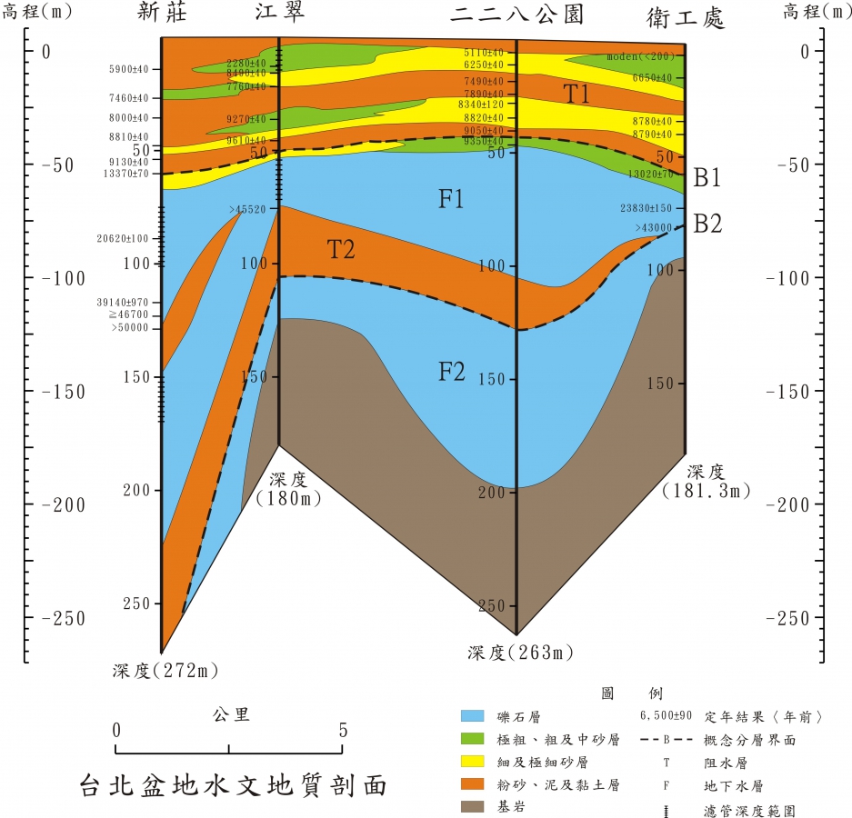
Figure 4.2-1 Hydrogeological section of Taipei Basin
References: 1. "Compilation of the results of the overall plan for the groundwater observation network in Taiwan (81-97)"
2. "Taiwan region hydrogeological zoning characteristics", Central Geological Survey, 1997.
3.104 Annual monitoring and analysis of strata subsidence in Taipei, Chiayi, Kaohsiung and Pingtung

地層下陷防治資訊網 版權所有2018 Copyright © Information of Land SubsidencePrevention in Taiwan All rights reserved.
Hydrogeology
Taipei Hydrogeological Environment
