

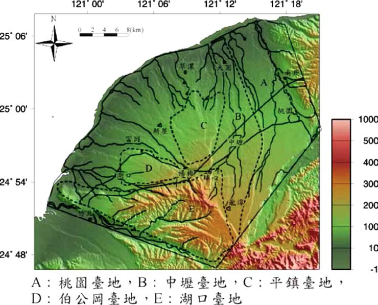
Figure 3.1-3 The relative position of each platform in Taoyuan platform group (Huang Mingzhe and Pan Guoliang, 1987)
The Pingzhen platform is a barrier-shaped terrain at the southeast of 180 meters above sea level; the Bogonggang platform is located west of Shezi Creek across the Pingzhen platform, and the south side is also opposite to the Hukou platform, which is heart-shaped. The southeast elevation of 160 meters above sea level is also a barrier-like terrain, and the terrain is gradually decreasing toward the west; the Hukou platform is approximately located in the south of the Puxin-Hukou connection, which is a hilly cutting platform and the northern edge of the platform An east-west gully-shaped longitudinal valley plain faces Bogonggang and Pingzhen. It adjoins the Zhongli platform in the east and reaches the Fengshanxi river bed in the south. The topography is about east high and west low (Central Geological Survey, 2001).
The most obvious geological environment characteristics of the Taoyuan platform group are a series of Quaternary platforms with different heights and slightly arranged in a step-like arrangement; these platforms are the main part of the alluvial fan of ancient Shimen. The slope is gently inclined; the surface layer of the platform is mostly red clay gravel layer, and the east side of the platform is based on the Xinzhuang fault as the boundary between the tectonic area and the western foothill belt of the Tertiary orogeny (Figure 3.1-4); the Hukou fault is the platform The main fault on the group; only the Pingzhen anticline on the north side of the fault; the south side of the fault has the Yangxiwo fault, Hukou anticline and Xinpu syncline in sequence.
The surface of the Taoyuan platform is covered with red clay about 5 meters thick. These red clays have poor water permeability, so they can be used to store rainwater as ponds in a "pi" way. Down is a gravel layer about 20-40 meters thick, which should be distributed in the whole area, as the upper groundwater layer and as a free aquifer. Further down are the alternating layers of finer-grained sandstone and shale, which is the lower groundwater layer. The detailed distribution of the thick sandstone is unknown. There are roughly three or more aquifers. This is the pressured aquifer in this area (Jiang Chongrong) , 2000; Jian Jinshu and Lin Daoguo, 1990). In this area, the gravel layer is quite hard and the compressibility of sand and shale is quite low, so the potential for serious subsidence is not high.
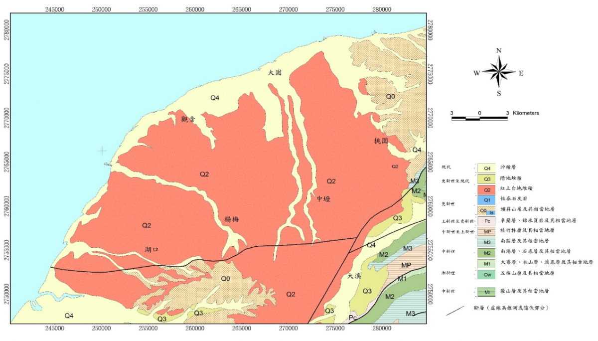
Figure 3.1-4 Regional Geological Map of Taoyuan Platform Group (Central Geostationary Research Institute, 2000)
Note: The accuracy of the original geological map is one half a million geological map
The surface of Taoyuan Zhongli area is widely distributed laterite gravel layer, the average laterite gravel thickness is about 20 meters. Below the red soil gravel layer is the bayberry layer, mainly composed of marine fine sand and mud interbed to the coastal sea-land interface.
Comprehensive analysis of the drilling core and lithofacies combination and its sedimentary environment, the Longtan well with the highest position on the topography, the entire section of the core shows that it is formed by alluvial rivers on land. As for the lowest in topography, that is, Guanyin and Dayuanjing, which are just on the seashore, there are lithofacies of semi-fresh water channels and wetlands where marine and continental phases interact. The Nanshi, Toutzhou, Dongming, Yangming, Zhongli, and Shandong wells, which are between the two wells in the topography, present a rock facies combination of the meandering river. These cores appear from deep to shallow, and the lithofacies sequence with coarser particle size upwards and shallower sedimentary environment shows that the entire alluvial fan is expanding outwards
The main aquifer in this area can be divided into two layers. The first layer is the surface terrace gravel layer, including late Pleistocene red soil gravel layer and Holocene river step gravel; the second layer is the underlying Pleistocene bayberry layer sand layer. Contains the mirror section and the gate section.
The surface terrace gravel aquifer is widely distributed in the whole area, showing the distribution pattern of ancient alluvial fans, with the east high and the west low, and the gravel particle size decreases towards the west.
The analysis of the lithofacies combination and sedimentary environment of the bayberry layer aquifer, the station well near the foothills on the east side, the core is mainly formed by the accumulation of terrestrial gravel, and the particle size gradually becomes thinner towards the sea side, becoming mainly marine strata. This aquifer is in the development of paleo-alluvial fans, which accumulates from the fan head of the continental facies to the fan margin of the sea. At the same time, it is the uplift of the new stage structure. The aquifer developed along the alluvial fan is also inclined westward as shown in Figure 5.2-1 and Figure 5.2-2.
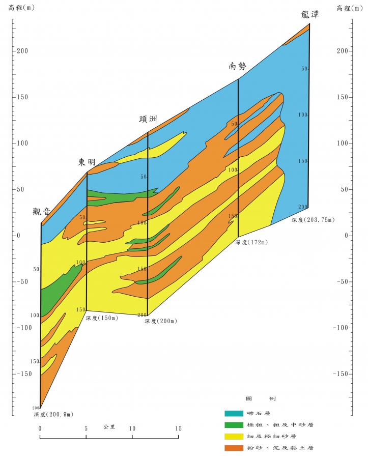
Figure 5.2-1 Rontan to Guanyin geological profile
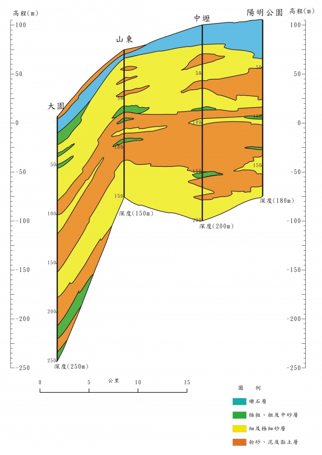
Figure 5.2-2 Geological profile from Yangming Park to Dayuan
Judging from the existing resources, the eastmost tan and bayberry are located at the top of the ancient alluvial fan, mainly composed of gravel. With the development of the alluvial fan system to the west, the strata gradually changed into sand interlayer. To the station well near the sea on the west side, because the soil layer is thin and has many layers, many water blocking layers are formed in the vertical direction. For Huxing Station and Yongan Station, at least 300 meters deep, at least four aquifers can be separated. The first layer is the shallowest gravel layer. The lower layer is complicated, and it is roughly 50 meters thick. The water level difference between the first aquifer (shallow layer for short) and the second to fourth aquifer (deep layer) is very large, taking Huxing Station as the sub-level, the shallow water level is about 4 meters, while the second, third and fourth aquifers They are 20, 29, and 29 meters, respectively, with a difference of 10 to 20 meters.
At present, the station with the deepest water level measured is Well No. 3 of Huaxing Station, which is located next to the Hsinchu Industrial Zone (the administrative area belongs to Hsinchu, but the hydrogeological zone belongs to the Taoyuan platform, or Taoyuan-Zhongli-Hsinchu platform), and observation well 1 ( Well depth 25 meters) 6.7 meters below the water surface, observation well No. 2 (well depth 110 meters) 47 meters below the water surface, observation well No. 3 (well depth 180 meters) 67 meters below the water surface. The most observation wells under the water level are usually located next to the industrial zone, such as the Zhongli Industrial Zone and the Guanyin Industrial Zone. Early factories used pumping wells with a depth of about 100 to 200 meters. When the water level is lower than ten, it usually needs to be drilled to 400. Only meters have enough water.
Most of the groundwater quality in the Taoyuan platform is very light. Wells such as sea lakes and trees on the seaside are also highly conductive, ranging from 300 to 500 micromhos per centimeter. Only the first aquifer at Huaxing Station is slightly higher and conductivity up to 1391 micromhos per cm.
The first aquifer of the Taoyuan platform was one of the residents’ drinking water in the early days, but it was more likely to be polluted due to its proximity to the ground. The famous "RCA Taoyuan Factory" caused the first aquifer to be polluted by the penetration of tetrachloroethylene into the ground. Spend 了 huge amount of renovation costs, the factory area is still deserted. In the early factories, due to the high environmental requirements, the barrels of solvent or waste oil were stored in the storage yard. If there is no isolation facility, such as water or permeable cloth, these pollutants are very easy to penetrate into the ground. According to the research by Professor Yiping of the Department of Geology of National Taiwan University, the first aquifer is mainly gravel, with good permeability and good pollution, and the pollution is easy to spread to the downstream.
The Taoyuan platform is continuing to be weathered into red soil, with erosive river trenches. The ground sand and gravel layer of the Taoyuan platform is permeable and has the conditions to become an aquifer, but has two disadvantages:
1. Red soil with poor water permeability is spread all over the platform, which affects the infiltration of rainwater. In the past, the ancestors built ponds all over the Taoyuan platform to provide for living and irrigation.
2. the lack of replenishment of large rivers, drawing groundwater is equivalent to mining, and there is not enough natural supplement.
References: 1. "Compilation of the results of the overall plan for the Taiwan Groundwater Observation Network (81-97)".
2. "Taiwan region hydrogeological zoning characteristics", Central Geological Survey, 1997.
3. "104 years of monitoring and analysis of formation subsidence in Taipei, Chiayi, Kaohsiung and Pingtung".