

The Tainan area is located in the southern part of the west coast of Taiwan's main island. It is the middle and southern section of the Jianan Plain. The administrative area is mainly in Tainan City. The area is bounded by Bazhangxi and Chiayi in the north, Errenxi and Kaohsiung in the south, Chiayi hills to the west-Xinhua hills to the west, and the Taiwan Strait to the west. This area is mainly a plain area, which is adjacent to the foothills on the eastern edge of the plain, and the Alishan Mountain Range on the further east side. The terrain division is shown in Figure 3.1-8.
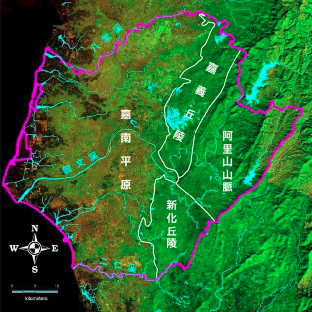
Figure 3.1-8 Terrain zoning map of Tainan
The surface geology of this subarea is mainly modern alluvial strata (as shown in Figure 3.1-9), and the hilly land on the eastern periphery exposes Pliocene to Pleistocene strata, including Zhuolan strata (equivalent strata), Guting pit strata, and head The Jishan layer (equivalent stratum) and platform accumulation layer; the mountainous area to the east of the hills (to the east of the Dajianshan fault and Zuozhen fault) exposes the Miocene to Pliocene strata, with Nanzhuang layer (equivalent layer), Gui Bamboo forest layer (equivalent stratum), Zhuolan layer (equivalent stratum) and Tou Geshan layer (equivalent stratum). The Central Geological Survey carried out hydrogeological survey and research on the Jianan Plain during the 88-92 years of the Republic of China, and analyzed the sediments, paleotopography and new structure of the Jianan Plain. The results are shown in Figure 3.1-10 (Central Geological Survey, 2007) .
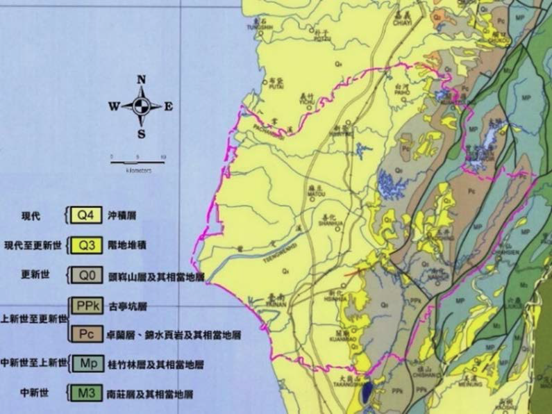
Figure 3.1-9 Regional geological map of Tainan (Central Geological Survey, 2000)
Note: The accuracy of the original geological map is one half a million geological map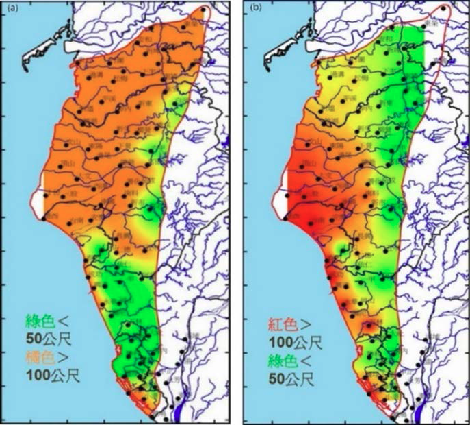
Figure 3.1-10 Distribution map of base depth (a) and Holocene sediment thickness (b) in the Jianan Plain (Central Geological Survey, 2007)
The thickness of the Holocene alluvium in the region varies from 200 meters in the north to 50 meters in the south; from 16 to 36 meters in the Tainan platform, it increases from west to Anping to 175 meters, and from north to 60 meters ~80 meters (Water Resources Bureau, Ministry of Economic Affairs, 2001). The strata in the Jianan Plain are complex, mostly interbedded with sand and mud. The stratification is obvious but the continuity is not good, the thickness varies greatly, and there is no significant water blocking layer (especially thick mud layer) and aquifer (sand layer). Not good. The hydrogeological characteristics are roughly bounded by brine streams, roughly divided into south and north sections. The northern section covers areas such as Chiayi and Tainan. The Tainan area is located in the southern section of the northern section. The deposition rate is affected by changes in the sea surface since the Quaternary The sedimentation rate increases toward the south, but the grain size decreases toward the south. The connectivity of the groundwater layer is generally good except for the area near the foothill zone (Lai Dianzhang et al.; 2003).
In the north-south geological section from Jinhu to Tainan in Tainan (see Figure 3.1-11), the hydrogeology within a depth of about 250 meters can be divided into four layers: the first layer is about 70 meters deep from the surface to the underground, The aquifer gradually thickens southwards from Jinhu Lake, and is the thickest at Tainan Station; the second layer is distributed between 75 and 125 meters. The aquifer is more pronounced in the Dingshan and Tenth areas, and thins toward the north and south respectively; The three layers are distributed between 125 and 180 meters. The aquifer is in the shape of a convex mirror. The Jinhu station and Tainan station at the north and south ends are more prominent. The fourth layer is below 180 meters, and the proportion of the sand layer is extremely low. It is distributed in a thin convex lens body, and there is no obvious aquifer in this layer. Overall, the distribution of the aquifer in the Tainan station south of the Tainan area is better.
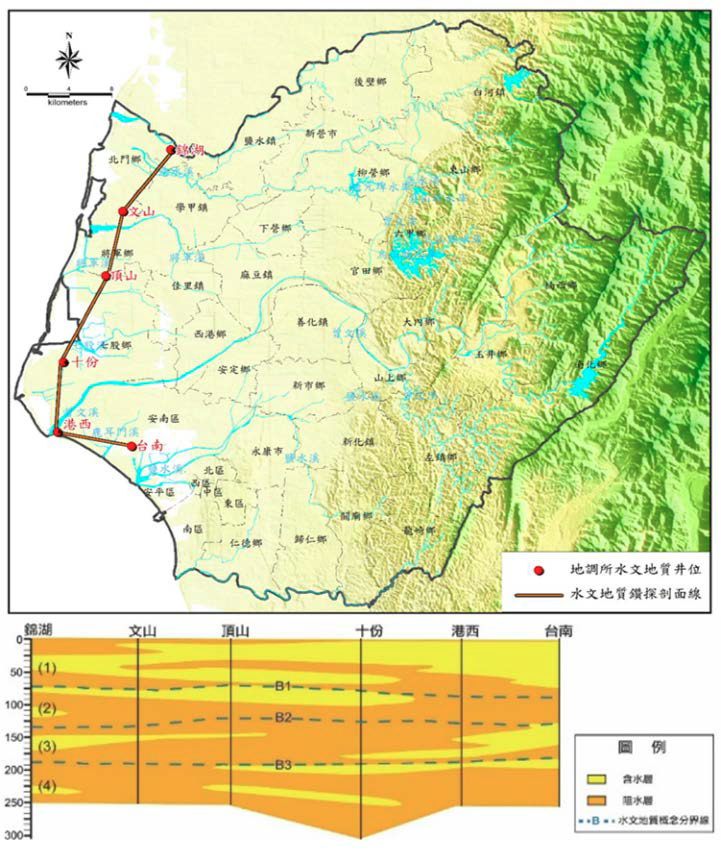
Figure 3.1-11 Geological profile and hydrogeological concept layered map of Tainan area
This article refers to the 2017 subsidence monitoring and analysis of the Taipei, Taoyuan, Chiayi, Tainan and Pingtung regions planned by the Water Resources Agency
Figure 3.1-8 Terrain zoning map of Tainan
The surface geology of this subarea is mainly modern alluvial strata (as shown in Figure 3.1-9), and the hilly land on the eastern periphery exposes Pliocene to Pleistocene strata, including Zhuolan strata (equivalent strata), Guting pit strata, and head The Jishan layer (equivalent stratum) and platform accumulation layer; the mountainous area to the east of the hills (to the east of the Dajianshan fault and Zuozhen fault) exposes the Miocene to Pliocene strata, with Nanzhuang layer (equivalent layer), Gui Bamboo forest layer (equivalent stratum), Zhuolan layer (equivalent stratum) and Tou Geshan layer (equivalent stratum). The Central Geological Survey carried out hydrogeological survey and research on the Jianan Plain during the 88-92 years of the Republic of China, and analyzed the sediments, paleotopography and new structure of the Jianan Plain. The results are shown in Figure 3.1-10 (Central Geological Survey, 2007) .
Figure 3.1-9 Regional geological map of Tainan (Central Geological Survey, 2000)
Note: The accuracy of the original geological map is one half a million geological map
Figure 3.1-10 Distribution map of base depth (a) and Holocene sediment thickness (b) in the Jianan Plain (Central Geological Survey, 2007)
The thickness of the Holocene alluvium in the region varies from 200 meters in the north to 50 meters in the south; from 16 to 36 meters in the Tainan platform, it increases from west to Anping to 175 meters, and from north to 60 meters ~80 meters (Water Resources Bureau, Ministry of Economic Affairs, 2001). The strata in the Jianan Plain are complex, mostly interbedded with sand and mud. The stratification is obvious but the continuity is not good, the thickness varies greatly, and there is no significant water blocking layer (especially thick mud layer) and aquifer (sand layer). Not good. The hydrogeological characteristics are roughly bounded by brine streams, roughly divided into south and north sections. The northern section covers areas such as Chiayi and Tainan. The Tainan area is located in the southern section of the northern section. The deposition rate is affected by changes in the sea surface since the Quaternary The sedimentation rate increases toward the south, but the grain size decreases toward the south. The connectivity of the groundwater layer is generally good except for the area near the foothill zone (Lai Dianzhang et al.; 2003).
In the north-south geological section from Jinhu to Tainan in Tainan (see Figure 3.1-11), the hydrogeology within a depth of about 250 meters can be divided into four layers: the first layer is about 70 meters deep from the surface to the underground, The aquifer gradually thickens southwards from Jinhu Lake, and is the thickest at Tainan Station; the second layer is distributed between 75 and 125 meters. The aquifer is more pronounced in the Dingshan and Tenth areas, and thins toward the north and south respectively; The three layers are distributed between 125 and 180 meters. The aquifer is in the shape of a convex mirror. The Jinhu station and Tainan station at the north and south ends are more prominent. The fourth layer is below 180 meters, and the proportion of the sand layer is extremely low. It is distributed in a thin convex lens body, and there is no obvious aquifer in this layer. Overall, the distribution of the aquifer in the Tainan station south of the Tainan area is better.
Figure 3.1-11 Geological profile and hydrogeological concept layered map of Tainan area
This article refers to the 2017 subsidence monitoring and analysis of the Taipei, Taoyuan, Chiayi, Tainan and Pingtung regions planned by the Water Resources Agency