

Geologically, the Kaohsiung Division is located on the southwestern edge of the Western Foothills Geological Zone. The plain ground geology is modern alluvial layer and Pleistocene uplift limestone; the east foot mountain zone exposes Youtou mountain layer and platform accumulation layer (such as Note: The accuracy of the original geological map is one half a million geological map, as shown in the figure (Shown in 3.1-10).
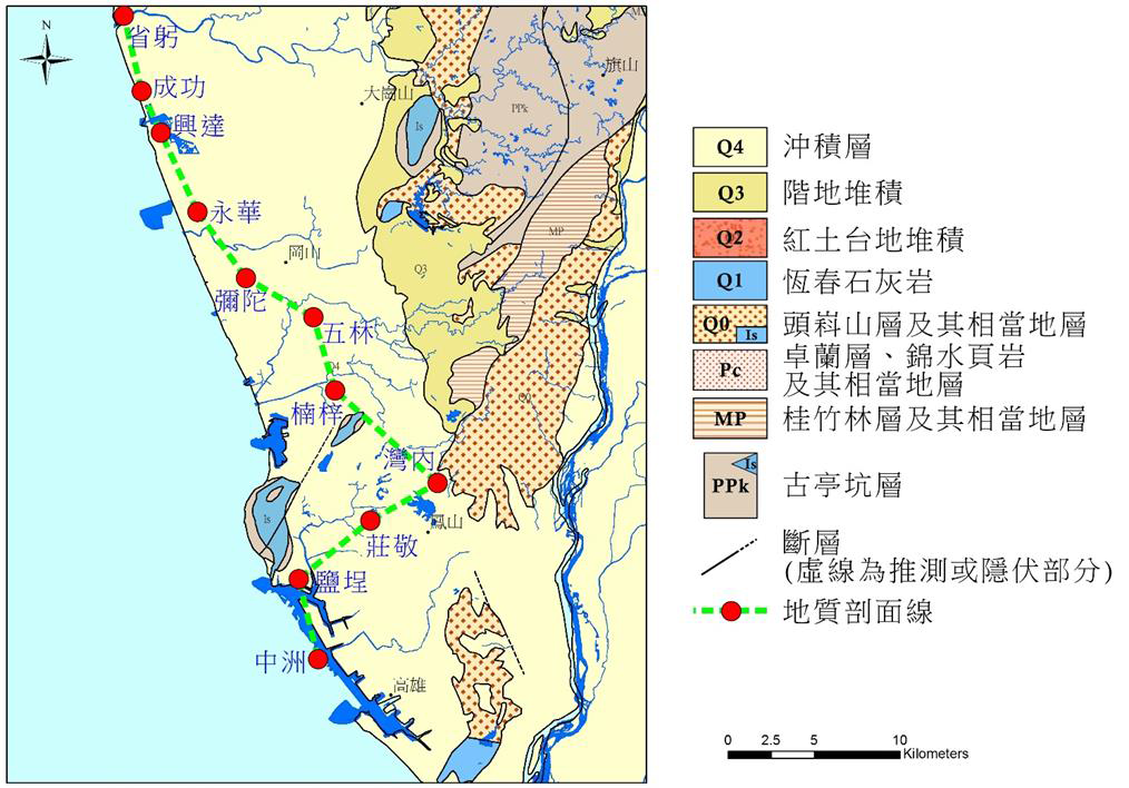
Note: The accuracy of the original geological map is one half a million geological map
Figure 3.1-10 Geological map of Kaohsiung
The alluvial layer is a combination of river deposits, coastal aeolian sand, and lagoon silt. The permeability is poor. Although there are many rivers, there are many muddy rock layers in the upstream, so the alluvial layer lacks coarse sediments; The edge is the thinnest and gradually thickens towards the west.
The limestone in this area is exposed in the hills and plains on the east side, which is a convex mirror body sandwiched between the guting pits. The Pleistocene strata in the Kaohsiung area equivalent to the "Tousushan stratum" are the Dashe stratum, the Guting pit stratum and the Nanshilun sandstone. The "platform accumulation layer" is distributed in the foothills of the front of the hills. Most of them are composed of unbound gravel and gentle sandy or silty convex mirrors sandwiched between them. Generally, the bedding and panning are very poor.
The Kaohsiung area is located in the southern section of the hydrogeological zoning of the Jianan Plain (Lai Dianzhang et al., 2003). According to the observation results of the north-south section (Figure 3.1-11), the east-west depth of this section is less than 15 kilometers, due to structural influence The lithology varies greatly from station to station; the first aquifer is a shallow Holocene stratum. The proportion of sand layers at each station in this layer is extremely high, but its thickness varies greatly, so its connectivity needs additional evidence. verification.
The depth below the second aquifer is a sand-convex mirror body between mud layers. Except for Wulin Station and Zhongzhou Station, the thickness of the sand layer at each station is close to zero.
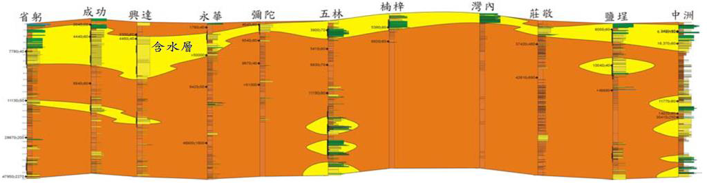
Note: For the drilling position in Figure 3.1-11, please refer to Note: The accuracy of the original geological map is one half a million geological map (Figure 3.1-10)
Figure 3.1-11 Kaohsiung area geological section and hydrogeological concept layered map
In the past, the Kaohsiung area was mainly tested in Kaohsiung County, where the depression in the Ganshan area was more obvious; and Kaohsiung City is the southern area of the Jianan Plain, with a fairly thick mud layer, and the sand layer is mainly distributed on the surface layer. The groundwater resources are not abundant, but if there is pumping behavior, the groundwater level will drop significantly, thus causing serious strata subsidence, belonging to the high potential area of strata subsidence, so most of the current areas are classified as land Water control area.
This article refers to the 2016 subsidence monitoring and analysis of the Taipei, Chiayi, Kaohsiung and Pingtung regions planned by the Water Resources Agency
Note: The accuracy of the original geological map is one half a million geological map
Figure 3.1-10 Geological map of Kaohsiung
The alluvial layer is a combination of river deposits, coastal aeolian sand, and lagoon silt. The permeability is poor. Although there are many rivers, there are many muddy rock layers in the upstream, so the alluvial layer lacks coarse sediments; The edge is the thinnest and gradually thickens towards the west.
The limestone in this area is exposed in the hills and plains on the east side, which is a convex mirror body sandwiched between the guting pits. The Pleistocene strata in the Kaohsiung area equivalent to the "Tousushan stratum" are the Dashe stratum, the Guting pit stratum and the Nanshilun sandstone. The "platform accumulation layer" is distributed in the foothills of the front of the hills. Most of them are composed of unbound gravel and gentle sandy or silty convex mirrors sandwiched between them. Generally, the bedding and panning are very poor.
The Kaohsiung area is located in the southern section of the hydrogeological zoning of the Jianan Plain (Lai Dianzhang et al., 2003). According to the observation results of the north-south section (Figure 3.1-11), the east-west depth of this section is less than 15 kilometers, due to structural influence The lithology varies greatly from station to station; the first aquifer is a shallow Holocene stratum. The proportion of sand layers at each station in this layer is extremely high, but its thickness varies greatly, so its connectivity needs additional evidence. verification.
The depth below the second aquifer is a sand-convex mirror body between mud layers. Except for Wulin Station and Zhongzhou Station, the thickness of the sand layer at each station is close to zero.
Note: For the drilling position in Figure 3.1-11, please refer to Note: The accuracy of the original geological map is one half a million geological map (Figure 3.1-10)
Figure 3.1-11 Kaohsiung area geological section and hydrogeological concept layered map
In the past, the Kaohsiung area was mainly tested in Kaohsiung County, where the depression in the Ganshan area was more obvious; and Kaohsiung City is the southern area of the Jianan Plain, with a fairly thick mud layer, and the sand layer is mainly distributed on the surface layer. The groundwater resources are not abundant, but if there is pumping behavior, the groundwater level will drop significantly, thus causing serious strata subsidence, belonging to the high potential area of strata subsidence, so most of the current areas are classified as land Water control area.
This article refers to the 2016 subsidence monitoring and analysis of the Taipei, Chiayi, Kaohsiung and Pingtung regions planned by the Water Resources Agency